
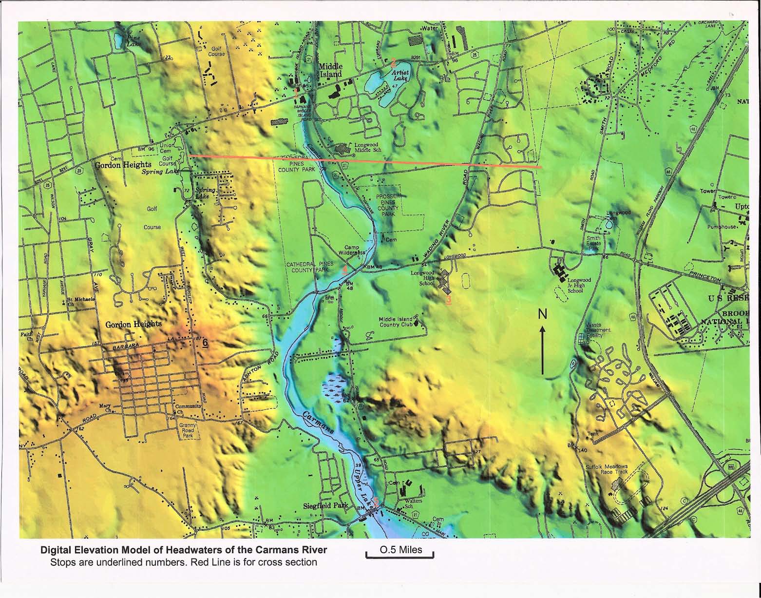
SCIENCE DRIVE of the CARMANS RIVER HEADWATERS |
|
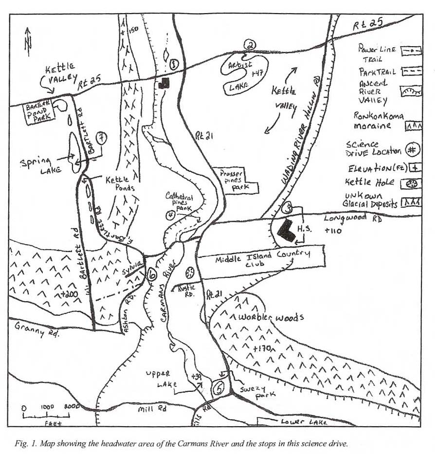
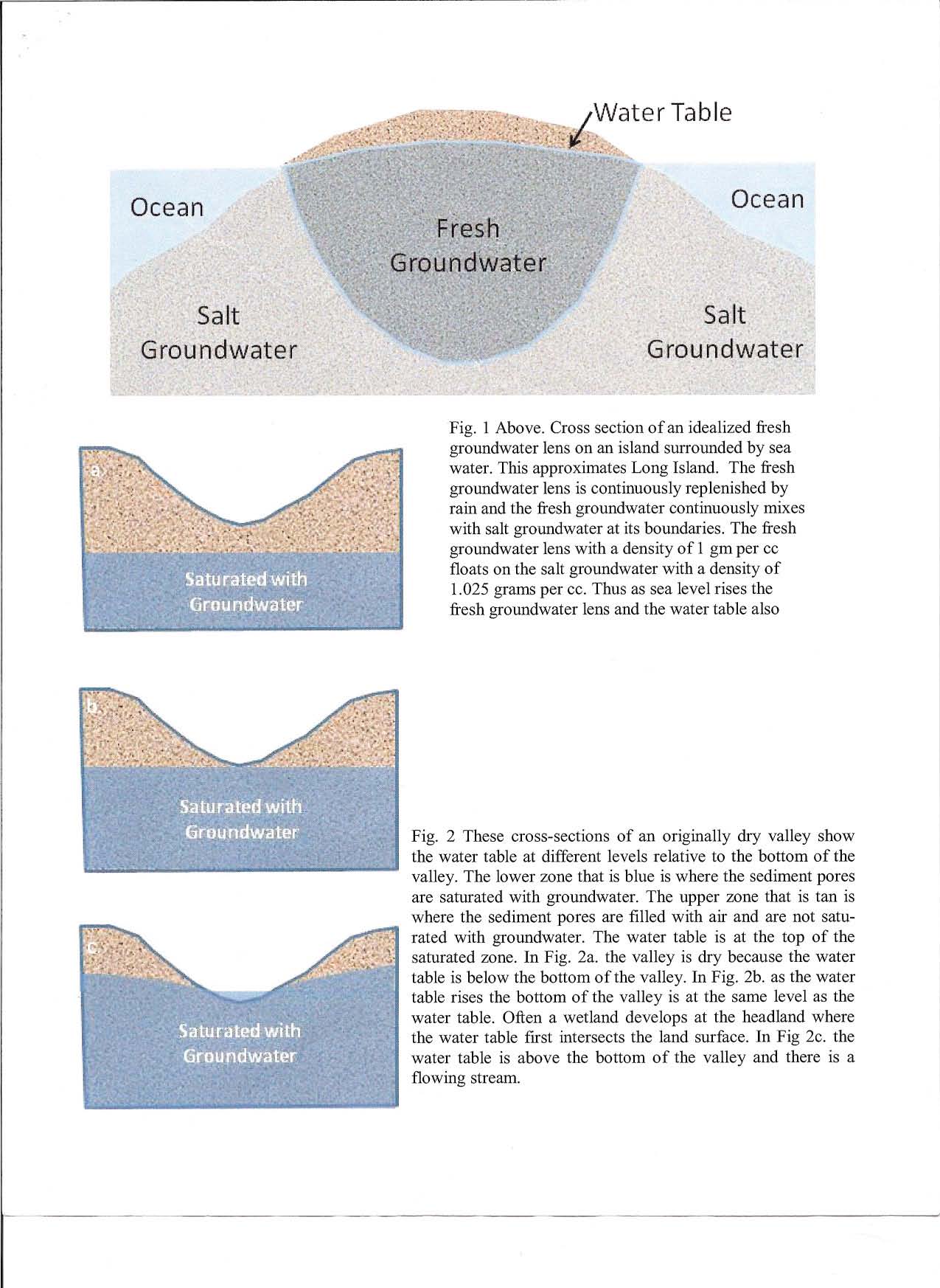
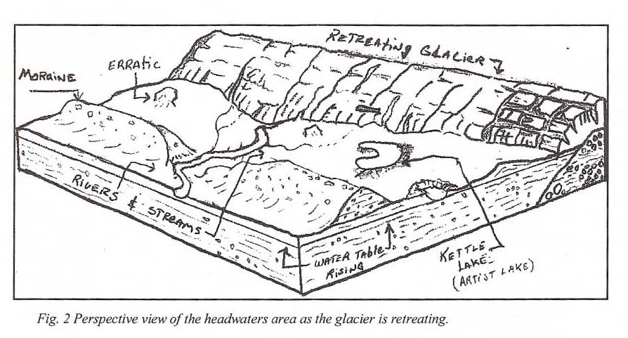
By Joseph Gabrinowitz, Dec. 2002; About twenty thousand years ago, the Wisconsinan glacier, which covered much of North America, reached the present location of Long Island leaving moraines and outwash plains. On Long Island there are two moraines: the Ronkonkoma Moraine in the center of Long Island that also forms the southern fork of. Long Island and the Harbor Hill Moraine along the North Shore of Long Island and that forms the northern fork of Long Island. Several wide and deep valleys on Long Island cut the Ronkonkoma Moraine and head toward the Great South Bay and the Atlantic Ocean. The Carmans River Valley lies within one of these valleys a larger ancient valley of unknown origin. Fig. 1 shows the extent of the larger ancient valley, which cuts the Ronkonkoma Moraine. The action of glacial ice and meltwater are likely suspects for the formation of this valley. The valleys contain depressions that are now filled with water. They have been called kettle ponds or lakes, yet it is not clear that they fonned as kettles. Kettles form when blocks of ice, which become surrounded by sediments, melt. If the groundwater table intersects the bottom of the kettle it becomes a kettle lake or kettle pond ( see Fig. 2 of handout.) Branching tributaries can be seen on the Digital Elevation Model or in the areas shown as kettle valley in (Fig. 1). The tributary valleys begin near the north shore where they were draining the water produced by the Harbor Hill phase of the last glaciations. The water ran down East Bartlett Road on the west and down Wading River Hollow Road on the east as well as valley occupied by the Cannans River. As the glacier retreated these tributaries became dry. Later as sea level rose the water table also rose, the low-lying valley presently occupied by the Carmans River and some of the basins were flooded with groundwater ( See Fig. 1 and 2 in the handout.) The tributary on the east side of the Ancient Valley is still above the water table and is the site of Wading River Hollow Road. Just west of this valley is Artist Lake, a supposed kettle lake. The west side tributary left behind kettle valley topography, and several kettle lakes and ponds; the largest of which is Spring Lake. After you leave the Wal-Mart parking lot look down toward the Longwood Library, it is on the south side of Rt. 25 at the base ofthe hill (0.2 miles). Make a left turn at the stop light and park on the right side of the road. Be careful it will probably be muddy. Stop 1 . The elevation change from the top of the western wall of the larger Ancient Valley to this location is about 80 feet. The valley that the Carmans River and its estuary now occupy extends northward to Route 25A (-4 miles north of here). Remnants of the headwaters can be found in the small pond and wetland area here. You may see a ring of the common reed phragmites (a common invasive wetland plant), as you look northward into the woods. The phragmites tend to thrive in areas that are periodically submerged in water. Because current topographic elevation and the regional groundwater table elevation are about the same (-50' above mean sea level) these are a groundwater fed pond and wetland. That means the water table is at or above the land surface. See handout Fig. 2b. Continuing up the rise through Middle Island you are ascending the east side of the Carmans River Valley within the larger Ancient Valley. As you reach the top of the rise you are at an elevation of 90 feet above sea level. You should be able to see a lake in the valley to your right as you descend the rise. This is Artist Lake. Park in the parking lot alongside the lake on the right side of the road. About 0.6 miles from last stop. Stop 2.
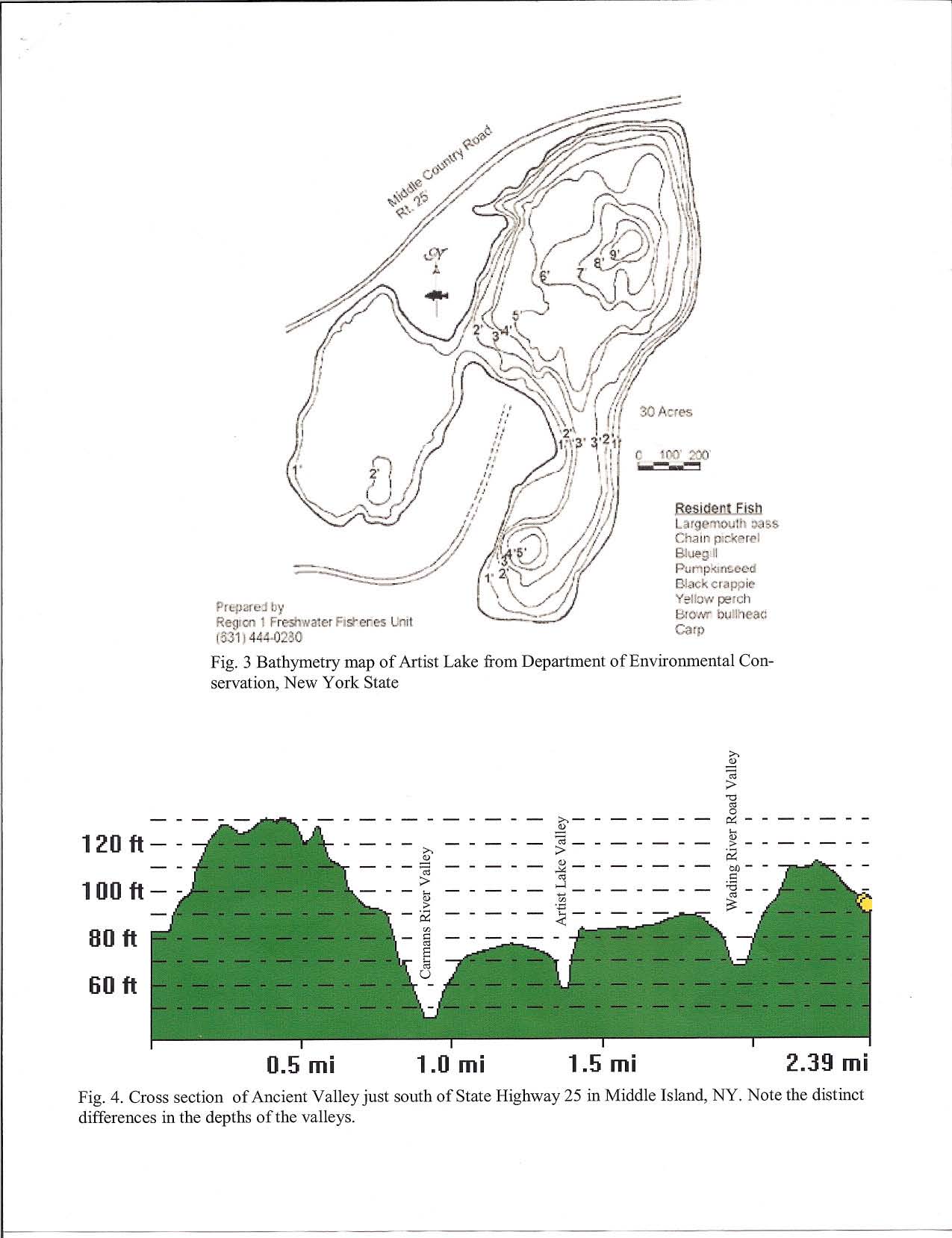
Artist Lake - The lake was given its name in the middle 1800s by locals who hoped to attract artists and painters to the area. It worked. A man by the name of Alonzo Chappel moved here in 1869. He painted historic revolutionary war scenes and historic people, which hang in museums all over the world. If you look at the map of the lake in Figure 2, you will see that it resembles a painters palette. The lake is believed to be a kettle lake and lies in the middle of the larger Ancient Valley. If it is indeed a kettle lake, can you imagine the size of the block of glacial ice that was buried here? However, like most of the lakes in the Ancient Valley it is very shallow .. Continuing east 0.7 miles on Route 25 you will ascend to a terrace, a fIat area within a valley. The terrace is just above the kettle valley topography and below the eastern wall of the Ancient Valley. At 0.7 miles make a right turn on Wading River Hollow road and continue to its end 1.5 miles south to Longwood Road. As you're driving, look to your left or east. Is there a significant change in elevation beyond the houses? This is the eastern wall of the Ancient River Valley (See Fig. 1). As you are traveling look to your right and you will notice a small wall. That is the western wall of the Wading River Hollow Road tributary. At Longwood road, make a left turn, drive to the top of the rise and turn right into the school grounds. Drive to the far end of the parking lot and park at the far southern end of the high school. Stop 3.
Longwood High school- Head west on Longwood Road to the intersection of Route 21 (0.25 miles) notice the change in elevation. At the end of Longwood road, directly across the street, lies Cathedral Pines County Park (stop3). Make a left turn onto Route 21 and quick right into the park. You can park in the lot on the south side of the road. Stop 4. Cathedral Pines County Park- At the south end of the parking lot is the beginning of a bike trail marked with a wooden sign. The trail is shown in Fig. 1 . The headwaters run parallel to the trail and then cross East Bartlett Road through a culvert to the Upper Lake (see Fig. 1). This culvert represents the transition ITom the headwaters to the beginning of the Upper Lake region of the Carmans River. The area is a major part of the fresh water wetlands that ring the park. The park and wetlands support a variety of wildlife, which include deer, several varieties of hawks, migratory birds (ducks, geese etc.), and egrets. The aquatic habits have been known to support trout, chain pickerel and many macroinvertebrates (bugs that live in or near water). The headwaters of many river systems are vital in the survival of the downstream ecosystems therefore; contaminants that could get into the river in this area could have significant impacts downstream. The land use in the area is mostly parkland, residential homes, and agriculture. What types of contaminants might you expect to occur in surface water runoff or in the groundwater? Exit the park and head south (miles) on Route 21 past East Bartlett Road and watch for the Middle Island Country Club, as you pass the entrance to the club notice that on the left or east of the road is a significant increase in elevation, while on the west side of the road there is a depression. This is the eastel11wall of the Ancient Valley where it cuts the Ronkonkoma Moraine (See Fig. 1). Continue south on Rt. 21 for 1.5 miles from the park. On your right before the traffic light is Swezey Park, Stop 5. Stop 5. Carmans River Upper Lake-Swezey Park - The upper and lower lakes of the Canllans River have been dammed since the late 1700s to early 1800s for conveying logs to a mill on the river in Yaphank. The mill no longer exists however; some historical buildings remain. Walk down to the shore and look too the northwest. The line of trees in the background is along the west side the Ancient Valley where it cuts the Ronkonkoma Moraine (See Fig. 1). Head back north on route 21 to East Bartlett road. Make a left turn onto East Bartlett and continue 0.5 miles west to the intersection of Ashton and East Bartlett roads. Make a left on Ashton and continue a 0.1 miles to Silvia Lane. Turn right and drive to the top of the hill about 0.1 miles. Stop 6. Western valley wall of Ronkonkoma Moraine - Walk south to the power lines. Hike uphill under the power lines for about 1/8 of a mile. Look back east to see your change in elevation. Continue up the hill for another 1/8-mile until you find utility pole #106 and look back east (for a better view climb to the top of the clift). The buildings in the distance are part of Longwood High School, which lies at the top Ancient Valley wall at stop 2. You are now standing in the trees we were viewing at stop 2 (about a mile away). The change in elevation from Silvia Lane to your current position is about 120 feet. The highest point of the moraine in this area is about 210 feet above sea level, impressive for Long Island. As you make your way down the moraine, look at the small drainage valley on the north side of the trail. Head north, back up Ashton Road to East Bartlett Road, at the intersection continue straight up east Bartlett for about a 1.5 miles. On your left or west side, you will start to see small ponds these are part of the continuing kettle valley topography that drained into the Ancient Valley from the west. (Look at your map to locate them). At the stop sign, you will see the Spring Lake Golf Club on your left. Proceed north, parallel to the course to a small park on the left (it is a gravel parking lot with a few picnic tables) this is stop 7, and great place to have a snack and enjoy the view. Stop 7. Spring Lake- Spring Lake is a kettle lake. A common misconception of kettle lakes is that the source of water is the melting of the glacier ice block. However, the melt waters would have seeped into the ground or evaporated shortly after their formation. The small ponds to the north of the main body of water are man made. They were constructed as a water hazard for the golf course, which was built in the 1950's. The ponds were once a partially submerged fresh water wetland that continued across Rt. 25, behind the strip mall and then a 1/2-mile west before drying up. The depressions were filled in to make way for new housing about the same time the golf course was built. Rt. 25 is just at the end of Bartlett Road. Turn right and go about 0.7 to the east on Rt. 25 to the Wal-Mart parking lot. As you head east notice that you are going over the western ridge to the Ancient Valley. Visit the web site at www.geo.sunysb.edu for copies of this Science Drive and other science walks on Long Island. Digital Elevation Model of Headwaters of the Carmans River. Stops are underlined numbers in red. Red line is location of cross section shown in Figure 4 View ... |